
About the eAtlas
Discover, learn, investigate and download environmental research and reference data for the Great Barrier Reef, its catchments, the Wet Tropics and the Torres Strait regions.
The eAtlas consists of a collection of regional and topic based atlases. Each of these provide content into the main eAtlas.
The eAtlas is a website and mapping system for presenting environmental research data in an accessible form that promotes greater use of this information. It is also a data management system for preserving and encouraging reuse of this data.
Decades of research have generated a large amount of data and information on the Great Barrier Reef and the terrestrial tropical ecosystems. Until now this information has generally been under-used. The eAtlas aims to promote collaboration and support the work of management agencies, researchers, reef-based industries and community groups.
From the site, users can discover what research is being done in a given region or on a given topic, then learn more about this research and its outcomes. The data behind the research can be investigated through an interactive mapping system and, where possible, the data itself can be downloaded. The eAtlas also contains a wide range of reference datasets that complement its research content.
The eAtlas is the primary data and knowledge repository for the National Environmental Science Programme Tropical Water Quality Hub and historically for the 38 NERP Tropical Ecosystems Hub projects, 6 Reef Rescue Marine Monitoring Program projects and the Marine and Tropical Science Research Facility. This research covers a wide range of topics some of which include: seagrass, coral reefs, turtles, dugongs, seabirds, bathymetry, fish abundance, Crown Of Thorns Starfish, rainforest revegetation, wet tropics species distributions, etc.
Funding history
The eAtlas was initially developed in 2008 and was originally called the Reef Atlas. It was changed to the eAtlas once its scope of content expanded to include terrestrial research from the NERP TE program. The eAtlas has been funded under a number of projects.
| Period | Project/Funding |
|---|---|
| 2008-2010 | Project 1.1.5: Marine and Tropical Science Research Facility (MTSRF) and the Australian Institute of Marine Science (AIMS) |
| 2010-2014 |
Project 13.1: National Environmental Research Program Tropical Ecosystem hub (NERP TE), Australian Institute of Marine Science (AIMS), with in-kind from Torres Strait.
|
| 2015 |
Project 3.13: National Environmental Science Programme Tropical Water Quality (NESP TWQ), Australian Institute of Marine Science (AIMS), with in-kind from Torres Strait Regional Authority (TSRA).
|
| 2016-2018 |
Project 2.3.5: National Environmental Science Programme Tropical Water Quality (NESP TWQ), Australian Institute of Marine Science (AIMS)
|
| 2019-March 2021 |
Project 5.15: National Environmental Science Programme Tropical Water Quality (NESP TWQ), Australian Institute of Marine Science (AIMS)
|
| 2022 to present |
National Environmental Science Program Marine and Coastal Hub (NESP MaC), Australian Institute of Marine Science (AIMS)
|
Partner sites
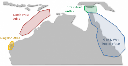
The eAtlas infrastructure now supports a number of related topic and regional atlases. These include the North West Atlas, the Torres Strait Atlas and the SELTMP eAtlas. Relevant content from any of these related atlases is automatically also available in the eAtlas.
The eAtlas has a legacy sister product, the Ningaloo Atlas, which was based on the same philosophy and technology.
Using the eAtlas
The primary purpose of the eAtlas is to provide access to research data in a manner that is useable by a broad range of users.
If you are interested in learning about general information about the environment check out the articles section.
If you are interested in finding data on a particular topic use the search to find metadata records, and from their you can get access to the data.
You can also use the interactive mapping system to find data and investigate the relationships between datasets using the visualised data. This mapping system draws on map services from not just the eAtlas but from other national marine portals.
Take a look at a recent presentation on the eAtlas and NESP TWQ data 'Making NESP research data accessible on the eAtlas'
Submitting data to the eAtlas
Most of the data that feeds into the eAtlas comes from research projects. If you have research data that would complement the existing catalogue please contact the eAtlas team (e-atlas@aims.gov.au). If you want to know more review the data submission FAQ.
Technical Overview
The eAtlas comprises five components:
-
A Website to host project pages, reports, articles (implemented in Drupal 6);
- An Enduring Repository of all the data, metadata, maps and scientific reports, implemented as a secure file store;
- Tools to assist in the preparation of datasets(implemented using R scripts, GDAL, and ArcMap);
- Mapping system provides visualisation of the research data, enabling quick previewing and inspection to allow users to see if the data is fit for purpose (implemented using GeoServer, ncWMS and AtlasMapper).
- Metadata catalogue to provide documentation on datasets and allow them to be discoverable (implemented using GeoNetwork and the AIMS Metadata viewer).
All the software in the eAtlas systems are open-source. More details of the eAtlas systems are described in the eAtlas Technical Overview Presentation.
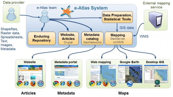
eAtlas basic architecture showing the flow of data from researchers through to the services provided by the eAtlas including: enduring repository, website, metadata catalogue, mapping and statistical tools