
Recent datasets
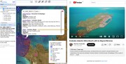
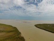
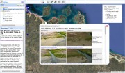
This dataset compiles georeferenced media - including videos (480), articles (20), and datasets (6) - specifically curated to facilitate the understanding of reef habitats across northern Australia. It was designed as a research tool for virtual fieldwork with a particular focus on identifying sources of information that allow an understanding of both inshore and offshore reef environments. This dataset provides a record of the literature and media that was reviewed as part of mapping the reef boundaries from remote sensing as part of project NESP MaC 3.17.
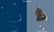
This code repository and dataset details a method for determining benthic reflectance from a combination of satellite imagery and bathymetry. Its key benefit is that it can map benthic reflectance up to 50 - 60 m in depth in clear waters, when using Sentinel 2 B2 channel combined with matching bathymetry data. Benthic reflectance is a measure of how much light the seafloor reflects and is useful for distinguishing areas that are sand (high reflectance) or vegetation such as seagrass, algae and coral (low reflectance).
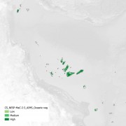
This dataset is a vector shapefile mapping the deep vegetation on the bottom of the coral atoll lagoons in the Coral Sea within the Australian EEZ. This mapped vegetation predominantly corresponds to erect macroalgae, erect calcifying algae and filamentous algae, with an average algae benthic cover of approximately 30 - 40%. Marine vegetation on shallow reef areas were excluded due to the difficulty in distinguishing algae from coral. This dataset instead focuses on the vegetation growing on the soft sediments between the reefs in the lagoons.
This record provides an overview of the NESP Marine and Coastal Hub project 'Supporting recovery and management of migratory shorebirds in Australia'. For specific data outputs from this project, please see child records associated with this metadata.
This record provides an overview of the NESP Marine and Coastal Hub project 'Towards assessing the values of reefs in the southern Gulf of Carpentaria 2024 - 2025'. For specific data outputs from this project, please see child records associated with this metadata.
This record provides an overview of the NESP Marine and Coastal Hub study - Assessing dugong distribution and abundance in the southern Gulf of Carpentaria. For specific data outputs from this project, please see child records associated with this metadata.
This record provides an overview of the NESP Marine and Coastal Hub study - Developing an Integrated Pest Management Framework for Feral Pigs in Coastal Environments. For specific data outputs from this project, please see child records associated with this metadata.
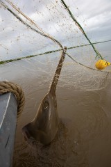
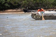
This record provides an overview of the NESP Marine and Coastal Hub project Indigenous Ranger-led monitoring of threatened sawfish in the southern Gulf of Carpentaria. For specific data outputs from this project, please see child records associated with this metadata.
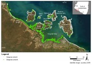
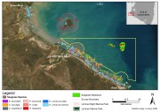
This dataset summarises benthic surveys in Yanyuwa Sea Country into 3 GIS shapefiles.
(1) A point (site) shapefile describes seagrass presence/absence at 3248 sites surveyed by small vessel and helicopter.
(2) The meadow shapefile describes attributes of 180 intertidal seagrass meadows.
(3) The interpolation GeoTiff describes variation in seagrass biomass across the seagrass meadows.
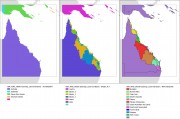
This dataset collection contains GIS layers for creating the AIMS eReefs visualisation maps (https://ereefs.aims.gov.au/). These datasets are useful for creating A4 printed maps of the Great Barrier Reef and the Coral Sea. It contains the following datasets:
- Countries - Australia plus surrounding countries at 1:10M scale. Crop of Natural Earth Data 1:10 Admin 0 - Countries dataset. Allows filtering out of surrounding countries.
- Cities - 21 Cities along the Queensland coastline.
This generated data set contains summaries (daily, monthly) of the eReefs CSIRO river tracers model v2.0 (https://research.csiro.au/ereefs) outputs at 4km resolution, generated by the AIMS eReefs Platform (https://ereefs.aims.gov.au/ereefs-aims).
This record provides an overview of the NESP Marine and Coastal Hub study - Project 3.11 - Multi- fishery collaboration to assess population abundances and post release survival of threatened sawfish in northern Australia. For specific data outputs from this project, please see child records associated with this metadata.

This record provides an overview of the NESP Marine and Coastal Hub small-scale study - Project 3.9 - Establishing an Indigenous led approach to coordinated vertebrate pest management in northern Australia. For specific data outputs from this project, please see child records associated with this metadata.
This record provides an overview of the NESP Marine and Coastal Hub study - Project 3.5 – Supporting regional planning in northern Australia: Building knowledge, skills and partnerships for understanding seagrass distribution. For specific data outputs from this project, please see child records associated with this metadata.
This record provides an overview of the NESP Marine and Coastal Hub small-scale study - Project 3.4 – Better Management of Catchment Runoff to Marine Receiving Environments in Northern Australia. For specific data outputs from this project, please see child records associated with this metadata.
This record provides an overview of the NESP Marine and Coastal Hub small-scale study - Project 3.2 - Developing a National Indigenous Environmental Research Network – Marine and Coastal research case studies. For specific data outputs from this project, please see child records associated with this metadata.
This dataset summarises benthic surveys in Marra Sea Country, including the Limmen Marine Park (Commonwealth) and Limmen Bight Marine Park (Northern Territory) into 4 GIS shapefiles.
This project investigated the cause of the extensive areas of mangroves across the Gulf of Carpentaria which died in late 2015. Images from local fisherman showed extended impacted areas of more than 1,000 km where at least 7,400ha of mangroves had died in a matter of months. The project mapped the extent of the mass die-back, conducted aerial surveys to quantify shoreline condition, field studies to validate remote assessments and engaged with local aboriginal ranger groups to raise capacity for monitoring.
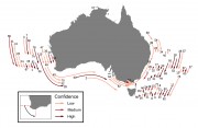
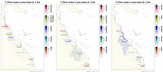
This dataset consists of the historical range limits and poleward-most extent of recent extralimital occurrence of 82 potential marine species’ range extensions around Australia (NSW, QLD, SA, TAS, VIC and WA) revealed by an assessment of citizen scientists observations from Redmap, Reef Life Survey, and iNaturalist from 2013–2022.
This dataset shows the tiling grid and their Row and Path IDs for Landsat 4 - 9 satellite imagery. The IDs are useful for selecting imagery of an area of interest. Landsat 4 - 9 are a series of Earth observation satellites, part of the US Landsat program aimed at monitoring Earth's land surfaces since 1982.