
Submitting data to the eAtlas
All datasets submitted to the eAtlas for publication need to complete an eAtlas dataset report form.
This form is for collecting documentation on environmental research datasets and aims to ensure that these datasets can be reused in the future by others. The information collected in this report should address the key questions someone would have when trying to understand and use the associated dataset.
Once complete please submit the following to the eAtlas team (e-atlas@aims.gov.au):
- Completed eAtlas dataset report form.
- Associated dataset files (as a zip file if there is more than one).
- Preview images (see Question 3 of the eAtlas dataset report form).
- Any associated reports and publications that help explain the dataset.
- Spatial extent CSV file (see Question 11 of the eAtlas dataset report form)
- Completed eAtlas Multiple Layer Upload Template if you have many GIS files. This will document each of the files and make it easy to upload them into the eAtlas mapping system.
If the associated data is too large to send via email (~ 50 MB limit) then use a file sharing service like Dropbox or CloudStor+. If the dataset is really large (> ~5 GB) then the eAtlas is happy to arrange sending a hard drive for the copy.
Once submitted the dataset will be reviewed by the eAtlas team prior to publication. For more information see the frequently asked questions page.
Submitting multiple GIS files
If you are submitting many GIS layers associated with a dataset please complete and supply the eAtlas Multiple Layer Upload Template spreadsheet along with your eAtlas dataset report form. This spreadsheet provides additional information about each of the layers that is needed for them to be displayed in the eAtlas mapping system. It will also assist anyone else using your dataset to understand what each of the files means. Each set of related GIS files (files associated with one dataset) MUST also be accompanied by an associated eAtlas dataset report form.
The preferred GIS file formats are GeoTiff and Shapefile however other formats can be processed (pretty much any format supported by GDAL or ESRI ArcMap) however it will require more preprocessing before we can upload the data to the mapping system.
If many of your layers are similar then in the eAtlas Multiple Layer Upload Template it is often useful to add extra columns that describe extra basic information each layer. You can then use spreadsheet string concatenations to create the titles and other fields. A handy trick is using the '&' to join together text columns. See "CONCATENATE WITH &" for examples of this. I use this approach when loading up all datasets with more than about 10 layers.
The image below shows where the title, description and paths you provide in the spreadsheet will be displayed in the mapping system.
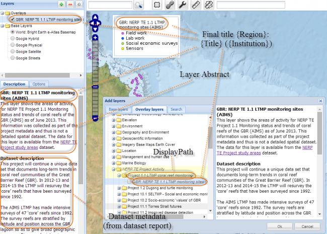
This image shows where the columns of the Multiple Layer Upload Template appear in the final eAtlas mapping system.