
Recent datasets
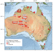
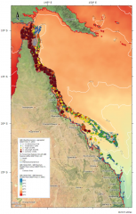
This dataset details the Declared Indigenous Protected Areas (IPA) across Australia through the implementation of the Indigenous Protected Areas Programme. These boundaries are not legally binding.
An Indigenous Protected Area (IPA) is an area of Indigenous-owned land or sea where traditional Indigenous owners have entered into an agreement with the Australian Government to promote biodiversity and cultural resource conservation.
An approved determination of native title is made by way of an order of the court pursuant to ss 86, 87 or 87A of the NTA or s 23 of the Federal Court of Australia Act 1976 (Cth).
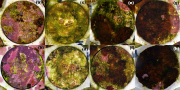
This dataset consists of three data files (spreadsheets) from a two month aquarium experiment manipulating pCO2 and light, and measuring the physiological response (photosynthesis, growth, protein and pigment content) of the adult and juvenile stages of two species of tropical corals (Acropora tenuis and A. hyacinthus).
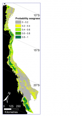
This dataset describes the predicted probability of seagrass presence across the Great Barrier Reef World Heritage Area and adjacent estuaries, based on six Random Forest models. The models have been mosaicked together into one raster dataset with 30m resolution.
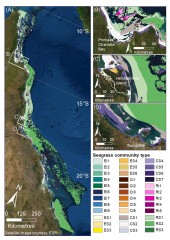
This dataset describes the predicted distribution of seagrass communities across the Great Barrier Reef World Heritage Area and adjacent estuaries, based on six multivariate regressions tree models for estuary intertidal, estuary subtidal, coastal intertidal, coastal subtidal, reef intertidal, and reef subtidal. The models are presented as six raster datasets with 30m resolution.
This dataset contains composite satellite images for the Coral Sea region based on 10 m resolution Sentinel 2 imagery from 2015 – 2021. This image collection is intended to allow mapping of the reef and island features of the Coral Sea. This is a draft version of the dataset prepared from approximately 60% of the available Sentinel 2 image. An improved version of this dataset was released https://doi.org/10.26274/NH77-ZW79.
This dataset contains cloud free composite satellite images for the northern Australia region based on 10 m resolution Sentinel 2 imagery from 2018 – 2022. This image collection was created as part of the NESP MaC 3.17 project and is intended to allow mapping of the reef features in northern Australia. This is a draft version of the dataset with the intention of improving clear water images with more sophisticated algorithms later in the project.
The last stream within the NESP 5.5 project was related to the conduct of an online survey to get aesthetic ratings of additional 3500 images downloaded from Flickr to improve the Artificial Intelligence (AI)-based system recognising and assessing the beauty of natural scenes, which had been developed in the previous NESP 3.2.3 project. Despite some earlier investment into this research area, there is still a need to improve the tools we use to measure the aesthetic beauty of marine landscapes.
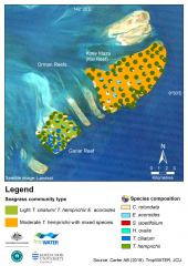
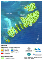
This dataset summarises intertidal benthic surveys of Kai and Gariar Reefs (Orman Reefs, Torres Strait) in November 2018 into 3 GIS shapefiles. (1) The site shapefile describes (a) seagrass presence/absence and (b) species composition at 124 sites. (2) The meadow shapefile describes seagrass communities for the two reef-top meadows. (3) The interpolation shapefile describes variation in seagrass biomass across sites for the two reef-top meadows.
This dataset summarises benthic surveys of seagrass for Dugong and Turtle habitats in the North-West Torres Strait for November 2015 and January 2016. The Site data describes seagrass at 853 sites; while the Meadow data describes seagrass at 34 individual meadows. The data includes information on seagrass species, biomass, diversity, and BMI and algae percent cover. The dataset is available as shapefiles, GIS layer packages, and/or a CSV file.
Methods:
This dataset summarises benthic surveys of seagrass for Dugong and Turtle habitats at Orman Reefs, Torres Strait. The site data describes seagrass coverage estimations at 279 intertidal sites; while the meadow data groups sites into six (6) individual meadows. Data captured includes information on visual estimates for seagrass species, substrate, biomass, diversity, percent cover for benthic macro-invertebrates and algae.
Methods:
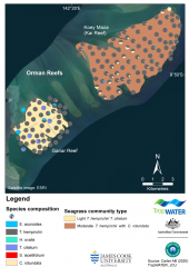
This dataset summarises intertidal benthic surveys of Kai and Gariar Reefs (Orman Reefs, Torres Strait) in September 2019 into 3 GIS shapefiles. (1) The site shapefile describes (a) seagrass presence/absence and (b) species composition at 124 sites. (2) The meadow shapefile describes seagrass communities for the two reef-top meadows. (3) The interpolation shapefile describes variation in seagrass biomass across sites for the two reef-top meadows.
This dataset is a compilation of available ocean temperature data, aerial and in-water bleaching observations during the 2016 and 2017 bleaching events on the Great Barrier Reef in order to estimate the total reef area impacted by coral bleaching and thermal heat stress. A total of 982 reefs (56.8% reef area of the GBR) were surveyed in 2016 and 781 reefs (50.9% reef area of the GBR) surveyed in 2017.
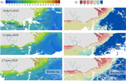
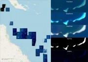
This dataset contains processed satellite imageries of the Golf of Papua - Torres Strait (GP-TS) region. It includes:
- 12-year (mid 2008-mid 2019) of daily MODIS water type images (Wet season colour scale), and summaries (seasonal, annual, long term, difference composite maps)
- 1 year (2019) of weekly Sentinel-3 water type images (Forel-Ule colour scale)
** This dataset is currently under embargo until 31/01/2022.
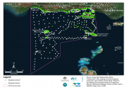
This dataset corresponds to the zoning of Commonwealth Marine Parks managed by Parks Australia.
This metadata is a non-authoritative extract maintained for the eAtlas. See links for the original and full metadata.
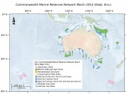
This dataset is not the current marine park zoning. It is retained here for historic purposes. See http://www.environment.gov.au/fed/catalog/search/resource/details.page?u... for current zoning.
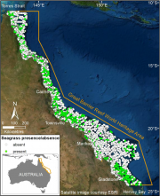
This dataset summarises 35 years of seagrass data collection (1984-2018) within the Great Barrier Reef World Heritage Area into one GIS shapefile containing seagrass presence and absence survey data for 81,387 sites.
This dataset contains code used to generate the daily benthic light (bPAR) data product provided at https://eatlas.org.au/data/uuid/356e7b3c-1508-432e-9d85-263ec8a67cef and the bPAR index for water quality in the Great Barrier Reef (GBR). It can also be used to calculate photosynthetically active radiation (PAR) at any specified depth in GBR waters.
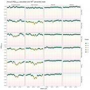
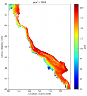
This dataset contains annual and seasonal values of the benthic light (bPAR index) for water quality on the Great Barrier Reef as calculated for each NRM Region (Cape York, Wet Tropics, Dry Tropics, Fitzroy and Mary-Burnett) and waterbody (Closed Coastal, Open Coastal, Midshelf and Offshore) for each water year between 2003 and 2019, as reported in NESP TWQ Project 5.3. Code used to produce these values is also available through eAtlas, as is the daily bPAR data.