
Recent datasets
This dataset shows the tiling grid and their IDs for Sentinel 2 satellite imagery. The tiling grid IDs are useful for selecting imagery of an area of interest.
Sentinel 2 is an Earth observation satellite developed and operated by the European Space Agency (ESA). Its imagery has 13 bands in the visible, near infrared and short wave infrared part of the spectrum. It has a spatial resolution of 10 m, 20 m and 60 m depending on the spectral band.
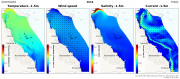
This data set contains summaries (daily, monthly, seasonal, annual) of the eReefs CSIRO hydrodynamic model outputs (GBR 4km v2.0 and GBR 1km v 2.0), covering water temperature, salinity and current at 6 depths (GBR1: 1.5m, 18m, 49m, 103m, 200m and 315m, GBR4: 2.35m, 18m, 49m, 103m, 200m and 315m). These summaries are aggregates derived from the original hourly model data made available via the National Computing Infrastructure (NCI).
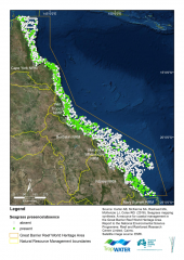
This dataset summarises 30 years of seagrass data collection (1984-2014) within the Great Barrier Reef World Heritage Area. The Site data describes seagrass at 66,210 sites; while the Meadow data describes seagrass at 1,169 individual or composite meadows. The data includes information on species, meadow type and age and reliability of the data. The dataset is available as shapefiles, GIS layer packages, and/or a CSV file. Data represented in this dataset has been collected by the TropWATER Seagrass Group and CSIRO in a GIS database.
This dataset consists of a review of case studies and descriptions of coral restoration methods from four sources:
1) the primary literature (i.e. published peer-reviewed scientific literature),
2) grey literature (e.g. scientific reports and technical summaries from experts in the field),
3) online descriptions (e.g. blogs and online videos describing projects), and
4) an online survey targeting restoration practitioners (doi:10.5061/dryad.p6r3816).
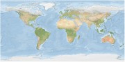
The Bright Earth eAtlas Basemap dataset collection is a satellite-derived global map of the world at a 1:1M scale for most of the world and 1:200k scale for Australia. This map was inspired by Natural Earth II (NEII) and NASA's Blue Marble Next Generation (BMNG) imagery.
Its aim was to provide a basemap similar to NEII but with a higher resolution (~10x).

This dataset shows the effects of eight herbicides (detected in Great Barrier Reef catchments) on the specific growth rates (from cell density data) of the microalgae Tetraselmis sp. during laboratory experiments conducted in 2019.

This dataset shows the effects of the insecticide imidacloprid on larval development of the hermit crab Coenobita variabilis. Experiments were conducted in 2017.

This dataset shows the effects of herbicides and one fungicide (detected in Great Barrier Reef catchments) on the specific growth rates (from cell density data) of the microalgae Tisochrysis lutea during laboratory experiments conducted from 2018-2019.

This dataset consists of shapefiles that correspond to the model grids used in the CSIRO eReefs hydrodynamic and biogeochemical models. These models store their results in multi-dimensional NetCDF files using a curvilinear grid. This dataset corresponds to an extract from these files converting the curvilinear grid into polygons in a shapefile. This dataset only captures the structure of the grid, not the time series data generated by the model.

This dataset consists of 1 excel data files (.xlsx format) that contains the results from the in situ deployment of instruments in Cleveland Bay to measure sediment deposition from a trailer suction hopper dredge working in Platypus channel. The aim of the study was to measure sediment deposition rates caused by a working Trailer Suction Hopper dredge in Platypus channel in Cleveland Bay.

This dataset consists of one data file (spreadsheet) from a 28-d experiment examining sediment-induced changes in the spectral quality and quantity of light on three coral species (Acropora millepora, Pocillopora verrucosa and Montipora aequituberculata) and one encrusting sponge species (Cliona orientalis).

This dataset resulted from two inter-linked research streams. The first stream was related to the application of eye-tracking technology and an online survey in studying natural beauty. The second stream is related to the development of an Artificial Intelligence (AI)-based system recognising and assessing the beauty of natural scenes. Due to differences in data collection and data analysis, details of research methods used for each research stream are described in three separated data records.
Five paired Control/Treatment gully sites on commercial grazing properties in the Upper Burdekin and Bowen catchments are being monitored as part of NESP Project 2.1.4 (Demonstration and evaluation of gully remediation on downstream water quality and agricultural production in GBR rangelands) (Bartley et al., 2018).
The key question being asked is: "Is there measurable improvement in the erosion and water quality leaving remediated gully sites compared to sites left untreated?" The monitoring approach uses a modified BACI (Before after control impact) design.

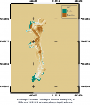
This dataset contains Riegl terrestrial laser scanner scans and their derived 5 cm gridded digital elevation models (DEMs) collected for up to 4 years between 2016 and 2019 for 4 paired Control/Treatment gully sites being monitored as part of NESP Project 2.1.4. Data collection also contains the DEMs of difference used to estimate changes in gully volume.

The aim of the study was to obtain light and turbidity vertical profile data through the water column in Cleveland Bay over a four-day period and during maintenance dredging to use for developing an empirical spectral solar irradiance model.

Australia's River Basins 1997 is the result of a joint State, Territory and Commonwealth Government project to create a national spatial database of major hydrological basins. It shows the boundaries of Australia's basins as defined by the Australian Water Resources Management Committee (WRMC).
Australia is divided into drainage divisions which are sub-divided into water regions which are in-turn sub-divided into river basins. The data includes the name and number of each of the 245 drainage basins, 77 regions, and 12 divisions.

This dataset contains preliminary estimates of discharge and loads (Total suspended sediment and total nitrogen) based on monitoring data collected for the NESP Project 2.1.4 Demonstration and evaluation of gully remediation on downstream water quality and agricultural production in GBR rangelands.

This dataset contains Water Quality monitoring data collected at the project gully sites for the three reporting wet seasons 2016-2017, 2017-2018 and 2018-2019.
The data in presented in this metadata are part of a larger collection and are intended to be viewed in the context of the project. For further information on the project, view the parent metadata record: Demonstration and evaluation of gully remediation on downstream water quality and agricultural production in GBR rangelands (NESP TWQ 2.1.4, CSIRO).

The climatology of the GBR temperature loggers is based on the hourly registers from loggers with 10 or more years of data, up to 2012 and for "Slope" and "Flat" locations on the reef.
The climatology is important as a reference point for comparison of future values. It also allows to compute the anomalies which represent the deviations from an established baseline. The data comes from the AIMS temperature loggers program and contains temperature registers as old as from 1991, providing for some sites, a time series of water temperature for more that 28 years.
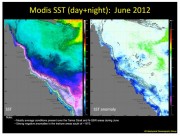
The Biophysical Oceanography Group produces monthly oceanographic reports for the eastern Australian coast, including the Torres Strait, which summarise key environmental variables such as sea surface temperature (SST) and chlorophyll concentration. These variables are important indicators for coral reef ecosystems and other biological processes.
This series of the reports covers from August 2011 - November 2014