
Recent datasets
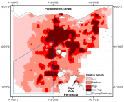
This dataset shows a raster spatial model of the distribution and relative density of dugongs (Dugong dugong) in the Torres Strait region based on an aggregate of 24 years (1987 - 2011) of systematic aerial surveys.

This dataset shows a spatial model of the distribution and relative density of dugongs (Dugong dugong) in the Torres Strait region based on an aggregate of 19 years (1986, 1987, 1992, 1994, 1999, and 2005) of systematic aerial surveys. For more information on the methods used in the creation of this dataset see Grech. A., and Marsh. H. (2007) - Prioritising areas for dugong conservation in a marine protected area using a spatially explicit population model, Applied GIS, 3(2), 1-14.
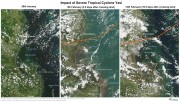
This collection is a record of MODIS satellite imagery before, during and after severe cyclone Yasi in February 2011. This image series highlights the damage the cyclone makes to the rainforest areas around mission beach and the turbulence created off shore by the cyclone on the 5th February (2.5 days after the cyclone). It corresponds to the images and maps from the "Cyclone Yasi satellite image maps - before and after" article in the eAtlas. Use this dataset if you wish to recreate these maps.
About 50 selected reefs throughout the Great Barrier Reef (GBR) are sampled in the AIMS Long-term Monitoring Project (LTMP). A visual census of fish on fixed transects (3 sites per reef, 5 x 50 m transects per site). Fishes from a list of 191 species, representing 10 families, are counted. \n \nIndividuals, Genus, Species are counted for a prescribed list of 212 species: all the parrotfishes, damselfishes, surgeon fishes, butterflyfishes, and some others. A full list of species observed each year are included in the appendices of each AIMS status report.

This dataset shows the concentrations of the herbicide glyphosate remaining over time in a simulation flask persistence experiment conducted in 2013.
Glyphosate degradation experiments were carried out in flasks according to the OECD methods for ‘‘simulation tests’’. The tests used natural coastal seawater and were carried out in the incubator shakers under 3 conditions: (1) 25°C in the dark, (2) 31°C in the dark and (3) 25°C in the light. The light levels were ~40 µE on a 12:12 light:dark cycle and the flasks shaken at 100 rpm for up to 330 days.

This very large study is published in Pitcher et al. (2007). Its purpose was to quantify patterns in seabed biodiversity and inter-reefal environmental conditions throughout the GBR.
Towed Video surveys down to a depth of ~50 m was completed successfully at the following shoals (Baracuda East, Goeree Shoal, Vulcan Shoal).
Towed Video surveys down to a depth of ~50 m was completed successfully at the following shoals (Baracuda East, Goeree Shoal, Vulcan Shoal).
Towed Video surveys down to a depth of ~50 m was completed successfully all at the following 9 banks and shoals (Baracuda East and West Shoals, Sheldon Shoal, Wave Governor Bank, Heywood Shoal, Echuca Shoal, Goeree Shoal, Eugene McDermott Shoal, Vulcan Shoal). Sampling involved habitat classification conducted in real-time during the surveys, and taking photographic still image at 10 s intervals for subsequent analysis as the cameras were towed across the shoals at a speed of 1-2 knots.
A total of 365 towed video transects were completed in the 2006/2007 surveys. The sampling has identified a vast array of habitats and will be used for broad scale mapping of benthic communities in the marine park, however further transect tows will be conducted in 2008 in areas of special interest, where sampling is considered limited and where ground-truthing is required. Towed video sampling effort was concentrated around Mandu, Osprey, Yardie, Winderabandi and Point Cloates in 2006.
Stereo Baited Remote Underwater Video Stations (BRUVS) were successfully deployed and retrieved at each of the 3 shoals (Baracuda East , Goeree Shoal, Vulcan Shoal). Deployments were restricted to <50 m depth and each unit was separated from its nearest neighbour by >250 m. In general 24 stereo BRUVS were deployed at each shoal.\n This project is a co-investment between PTTEPAA and AIMS, in order to build scientific knowledge on a number of shoal features in the area near Montara and was undertaken between 19/9/16 - 24/9/16.\n

Stereo Baited Remote Underwater Video Stations (BRUVS) were deployed and retrieved across two shoals of regional interest, Evans and Tassie Shoals, two of the closest shoals to the Barossa field. The allocation of deployment positions across each shoal was conducted using a regular/random design within the bounds of the 60 m depth contour whilst maintaining a minimum distance of 250 m between each stereo-BRUVS unit. Once the positions were derived, the sequence of deployments, in sets of eight replicate units, was determined by proximity and prevailing sea conditions on the day.

Towed video surveys were carried out in targeted shallow seabed environments within the proposed Oceanic Shoals Commonwealth Marine Reserve (CMR) in the Timor Sea. The survey concentrated on shelf habitats (< 200m) of the western part of the Oceanic Shoals CMR and included potential biodiversity hotspots such as pinnacles, banks and shoals. In total, 52 towed video transects were collected at depths of between 31 and 129 metres.

Towed video surveys were carried out across five principle locations of regional interest, including Evans, Tassie and Blackwood Shoals, the closest shoals to the Barossa field, as well as two mid-shelf seabed locations adjacent to Goodrich Bank and Cape Helvetius. In total, 113 towed video transects and 2246 downward facing digital still images were collected at depths of between 11 and 100 metres.

Towed video surveys between were carried out in targeted shallow seabed environments within and adjacent to the proposed Oceanic Shoals Commonwealth Marine Reserve (CMR) in the Timor Sea. The survey concentrated on shelf habitats (< 200m) of the Oceanic Shoals CMR and included potential biodiversity hotspots such as pinnacles, banks and shoals. In total, 48 towed video transects were collected at depths of between 17.2 and 89 metres.

Stereo Baited Remote Underwater Video Stations (BRUVS) were deployed and retrieved across targeted shallow seabed environments within and adjacent to the proposed Oceanic Shoals Commonwealth Marine Reserve (CMR) in the Timor Sea. The survey concentrated on shelf habitats (< 200m) of the Oceanic Shoals CMR and included potential biodiversity hotspots such as pinnacles, banks and shoals.
Towed video surveys were carried out in targeted shallow seabed environments within the proposed Oceanic Shoals Commonwealth Marine Reserve (CMR) in the Timor Sea. The survey concentrated on shelf habitats (< 200m) of the western part of the Oceanic Shoals CMR and included potential biodiversity hotspots such as pinnacles, banks and shoals. In total, 52 towed video transects were collected at depths of between 31 and 129 metres.
Stereo-Baited Remote Underwater Video Stations (BRUVS) were deployed and retrieved in targeted shallow seabed environments within the proposed Oceanic Shoals Commonwealth Marine Reserve (CMR) in the Timor Sea. The survey concentrated on shelf habitats (< 200m) of the western part of the Oceanic Shoals CMR and included potential biodiversity hotspots such as pinnacles, banks and shoals. In total, 56 stereo-BRUVS were deployed between 31 and 77 metres for one hour according to a regular random sampling design, with minimum spacing of 400 m to ensure independence among samples.

In NW Australia a range of emergent reefs bound the western margin of the Oceanic Shoals bioregion, but with the major feature being numerous submerged shoals lying along and across the shelf edge. Scott Reef, the largest emergent reef system, has a diverse shallow water coral reef ecosystem that has demonstrated impressive resilience to cyclone and coral bleaching disturbances over the last 15 years (Gilmour et al, 2013). The adjacent deeper lagoon of South Scott Reef covers approximately 300 km2 in depths of 30-?70m.
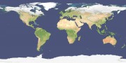
This layer shows a 500m resolution image of the world derived from the Blue Marble Next Generation April 2004 image (86400x43200 pixels).
As the image was derived from MODIS satellite imagery during Autumn in the Northern Hemisphere the high latitude countries (Russia, Canada, etc) are covered in snow.