
Recent datasets
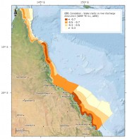
This dataset shows various statistics of photic depth across the Great Barrier Reef (GBR). Data are broken into 35 zones along and across the GBR and photic depth is derived from 11 years of MODIS Aqua data. The data included is:
1. The statistical strength of correlation between standardized photic depth and freshwater discharges the GBR.
2. The mean photic depth and the main physical environmental variables that need to be controlled for when assessing how volumes of river freshwater discharges influence photic depth.
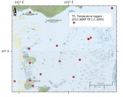
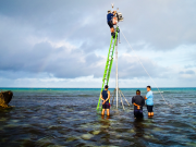
As part of the NERP TE project 2.3 temperature loggers were deployed at 15 sites across Torres Strait to measure the sea temperature. The loggers regularly measure the sea water temperature and record it in their memory. Every year or so the loggers are swapped with new loggers and the recorded data is extracted and recorded in the AIMS Real Time Data Systems database as part of the Australia wide Sea Temperature Observing System.

This dataset is subset and aggregation of the current Queensland land use dataset (1999 - 2012) by Queensland Land Use Mapping Program (QLUMP) produced by the Queensland Government. The land use data was classified and aggregated into areas that represent Human Use, Agriculture and Water areas such as lakes and rivers.
The aim of this component of the study was to determine how photosynthetic rates related to growth rates both into terms of skeletal deposition and organic carbon accrual associated with linear extension, and with organic carbon accrual associated with fat deposition or lipid enrichment of existent tissue. The study was based on the coral Acropora millepora located at Lizard Island (-14°40’, 145°27’) and at Heron Island (-23°26', 151°54') in the Great Barrier Reef (GBR) of Australia, with data collected for winter and summer months.

Boundaries of the Great Barrier Reef Marine Park proclaimed under Subsection 31(1) of the Great Barrier Reef Marine Park Act 1975 (CTH). For administrative purposes, the Amalgamated Great Barrier Reef Section is divided into four management areas.
This metadata record was created for the eAtlas and is not authoritative. Please contact GBRMPA for more information. To obtain this dataset go to the GBRMPA spatial information website, download the appropriate data usage agreement and send it through to gis@gbrmpa.gov.au.
The eAtlas is a website and mapping system for presenting environmental research data in an accessible form that promotes greater use of this information. It is also a data management system for preserving and encouraging reuse of this data.
The eAtlas is the primary data and knowledge repository for 38 NERP Tropical Ecosystems Hub projects, 6 Reef Rescue Marine Monitoring Program projects and historically, the Marine and Tropical Science Research Facility. It is now funded as the data repository for the NESP TWQ hub.
Project goals under the NERP TE (2010 - 2014):
This project developed a set of high quality GIS datasets of the emergent and shallow marine features (reef boundaries, reef tops, islands, and cays) of the Coral Sea Marine Park (CSMP). The goal of this mapping was to improve the precision and spatial detail of existing reef maps.

This dataset describes the areas of research activities for the 38 National Environmental Research Program Tropical Ecosystem (NERP TE) Hub projects. It represents the areas that have field work being conducted, where measurements have been taken and where modelling or analysis is being done.
It consists of three master shapefiles (points, lines and polygons) that capture the regions that are being studied by all these projects. These master shapefiles are also made available split by project.
This project will investigate how coral communities along the Great Barrier Reef have historically responded to acute (e.g. cyclones) and chronic (e.g. water quality) disturbances using pioneering high-precision geological dating and palaeoecological techniques, combined with high-resolution geochemical analysis of coral records.
This project will determine high resolution chronological records on different time scales over the past 1-2 millennia of parameters such as:
1. Sea-level based on high-precision dating and elevation survey of well-preserved microatolls;
The project will determine the status of threatened marine (green, hawksbill and flatback) turtles and dugongs in the Torres Strait and threats to these populations. It also will investigate links between different populations of dugongs and turtles in terms of movement and habitat use. They will also assess the abundance of dugongs in the Torres Strait using aerial surveys.
Working in conjunction with the Torres Strait Regional Authorities (TSRA) Land and Sea Unit and the TSRA Community Ranger program this project will:
Pesticides, and particularly herbicides from agricultural sources, have been detected in nearshore sites of the Great Barrier Reef (GBR) all year round. The actual impact from these concentrations of herbicides is under debate and information on cumulative impacts is required. To address this, a series of experiments will examine how plants and corals are affected by herbicides in the water in conjunction with other stressors such as temperature, low salinity and low light. An important source of herbicides in coastal waters is flood plumes from river runoff.
This project will determine the movement and habitat use of large predatory fishes such as sharks and coral trout in reef and coastal environments of the Great Barrier Reef. This project will employ acoustic monitoring technology in a series of inshore and offshore environments including coastal bays, inshore reefs and offshore reefs to monitor the presence and movements of predator species (elasmobranchs and teleosts).
The rezoning of the Great Barrier Reef Marine Park (GBRMP) in 2004 increased the number and extent of ‘no-take’ areas within the Park. This project surveys pairs of reefs, one in a ‘no-take’ or green zone and the other a similar reef where fishing is allowed (blue zone), in five regions of the GBRMP. Green and blue zones will be surveyed for the abundance and size of fishery species, particularly coral trout, as well as wider effects on coral reef communities. The results of reef surveys will be used to:
This project is providing a direct assessment of the ecological effects of multiple-use zoning on inshore reefs of the GBRMP. Underwater visual census (UVC) monitoring of fish and benthic communities is being carried out at 50 no-take marine reserve (green zone) sites and at 50 sites that have remained open to fishing within the Palm, Magnetic, Whitsunday and Keppel Island groups. Long-term monitoring surveys are providing information on:
1. The effects of no-take marine reserves on populations of both species that are fished and other non-fished species.
This project uses genetic parentage analysis, biophysical modelling and information on coral trout larval behaviour to determine patterns of recruitment of coral trout larvae within and among inshore and offshore reefs in the southern Great Barrier Reef. The overall goal of this project will be to assess larval dispersal patterns, demographic connectivity and levels of recruitment subsidies from green zones at a regional scale. Tasks include:

There are 10 major trading ports along the Great Barrier Reef coast. The waters of most of these ports are within the Great Barrier Reef Region, but not within the Great Barrier Reef Marine Park.
In recognition of the outstanding values of the Great Barrier Reef, there are stringent management arrangements for commercial shipping in the waters of the Great Barrier Reef, which is designated a Particularly Sensitive Sea Area by the International Maritime Organisation. Shipping traffic is confined to Designated Shipping Areas in the Great Barrier Reef Region.

This dataset consists of site means of the density of derelict fishing line, the percent cover of major benthic categories on fringing coral reefs of the Keppel, Whitsunday and Palm Island groups, and the accumulation rate of fishing line at ten sites in the Palm Islands between 2007 and 2009.
The data consists of ten minute readings of above water meteorological parameters (wind speed, wind direction, barometric pressure, air temperature and humidity) from a Vaisala WTX520 instrument, above water light as Photosynthetically Active Radiation (PAR) from a Li-COR Li-192 sensor and below water parameters including Salinity using a Sea-Bird SBE37 CTD and temperature via a Sea-Bird SBE39 temperature sensor. Data are from two sites, one at Madge Reef near Thursday Island (-10.595125° | 142.220572°) and one at Masig (Yorke) Island (-9.758293° | 143.397584°).
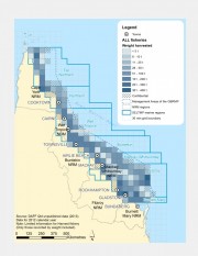
This dataset contains Active Licenses, Effort days, Harvest Weight and GVP for the Queensland commercial harvest, line, net, pot and trawl fisheries. The data is provided on a 30 min grid for locations where there are more than 5 licensed operators.
Commercial fishers and charter fishers are required by law to complete daily logbooks. Commercial fishing logbooks are used to record: overall catch, time spent fishing, location where catch was taken and fishing equipment used. This data is then managed by the Department of Agriculture, Fisheries and Forestry (DAFF).
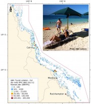
This dataset shows the spatial distribution of the number of visitors to the Great Barrier Reef Marine Park based on visitation rates collected from the Environmental Management Charge (EMC) managed by GBRMPA. The spatial information has been quantised into a 0.1 degree grid size.
This data only represents visitors to the Great Barrier Reef who used commercial tourist operations. Data is collected and updated quarterly following receipt of Environmental Management Charge returns from tourism operators. This dataset is a set of annual snapshots of this monthly data.