
Recent datasets
This data collection was started in 2005 as part of the Reef Plan. \n \nNearshore water quality data from direct water sampling by Niskin cast (suspended solids; chlorophyll; nitrogen, phosphorus and organic carbon species; silicate), summarised for the whole Great Barrier Reef and for each Natural Resource Management (NRM) region, by year (2005/06, 2006/07, etc.) and season (dry season, May-Oct; and wet season, Nov-Apr). Salinity, secchi depth, and temprature. \n \nFrom October 2007 data loggers are deployed at 14 sites to record readings of chlorophyll a and turbidity every 10 minutes.
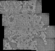
This dataset is a photo mosaic of historic aerial imagery of the southern Atherton Tablelands from 16th June 1978.
It includes the towns of Atherton, Malanda, Yungaburra and Tolga. It has a southern boundary just north of Millaa Millaa, a northern boundary of Lake Tinaroo, an eastern boundary of a quarter of Wooroonooran National Park and a western boundary of Atherton.
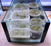
This dataset shows the measured response of the photosystems of seagrasses to herbicides in experiments conducted in 2012-2013. The data is provided as a multi-sheet spreadsheet.
The objective of this project is to assess how management of local stressors such as land runoff can help improve the resilience of coral reefs to global stressors (climate change) which are more difficult to manage. Complementary laboratory and field experiments will investigate the combined impacts of declining water quality (increased nutrients and sediments, and reduced light and salinity), increased sea temperature and ocean acidification on key reef species groups such as corals, foraminifera, crown-of-thorns starfish and rock-boring sea urchins.
Sediment samples for foraminiferan community analysis were collected from 20 reefs located between 13.5°S and 20.5°S within the Great Barrier Reef. Most of these reefs are inshore fringing reefs which can be grouped into three distinct geographical regions: eight reefs of the Whitsunday area (collected in August 2004), four reefs from Princess Charlotte Bay, and four from the Wet Tropic area (both collected in October 2004). Sediments were also collected from two midshelf reefs (Charity and Bait Reefs) in August 2004, and two outer shelf reefs (Hastings and Flynn Reefs) in January 2005.
This project investigates in detail the exposure and sensitivity of Wet Tropics animals to extreme climate and weather events, such as heat waves, fires, flooding rain and cyclones. This information will be used to assess and map the vulnerability of biodiversity to the impacts of current and future extreme events in the Wet Tropics bioregion. The information gathered in the Wet Tropics can potentially be applied to other regions in Australia and elsewhere to predict and mitigate the impacts of extreme climatic events on biodiversity.
The project seeks to improve understanding of practices that can underpin co-management arrangements for conservation areas, including the Wet Tropics World Heritage Area (WTWHA).
A co-research team of CSIRO scientists, Rainforest Aboriginal peoples, protected area managers and other key partners will investigate the potential of Indigenous Protected Areas (IPAs), and other collaborative models and tools, to engage Indigenous values and world views. The team will focus on the conditions under which these arrangements lead to effective joint management.
To support management of the Great Barrier Reef Marine Park, coral reef managers need decision support tools that can integrate physical and biological information at a variety of spatial and temporal scales. In this project we will construct vulnerability maps for the Great Barrier Reef (GBR) This project will deliver a novel framework for linking impacts of environmental change to spatial patterns of coral reef resilience and vulnerability.

This very large study is part of the Seabed biodiversity study, published in Pitcher et al. (2007). Its purpose was to quantify patterns in seabed biodiversity and inter-reefal environmental conditions throughout the GBR.
This project will develop a Management Strategy Evaluation (MSE) framework to build understanding of the key human uses and drivers of change in the inshore Great Barrier Reef (GBR), and to inform GBR stakeholders of the likely consequences, costs and benefits of particular management decisions that aim to minimise the impacts on biodiversity, particularly from inshore multi-species fisheries.

Climate change has emerged as the single greatest threat to coral reefs. The climate change threat will take many forms and includes projections that there will be higher abundances of coral diseases. Links have already been made between high temperatures and outbreaks of the disease ‘white syndrome’ in the Indo-Pacific but little is known about the disease due, in part, to not knowing where outbreaks will occur.

The purpose of this study is to detect and quantify spatial and temporal changes in reef fish assemblages of the Great Barrier Reef (GBR). Between 1993 and 2005, reef fish assemblages of 46 reefs were monitored annually along permanent transects within a standard habitat using visual census. The selected intensive survey reefs are distributed across three positions of the continental shelf and among six sectors each representing one band of latitude. These reefs continue to be surveyed in odd years as part of the Long Term Monitoring Program (LTMP).
This project focuses on relationships between socio-economic systems and the Great Barrier Reef (GBR). It comprises three interrelated activities to investigate:
1. Resident and tourist views about the relative ‘value’ of key ecosystem services that are provided by the reef. Researchers will design, distribute and analyse the results of a survey instrument to assess the relative value of different goods and services produced by the GBR to stakeholder groups using both traditional money-based valuation techniques and Larson’s non-monetary based technique.

This record details the TUMRAs that were in effect in 2009. Since then the number of TUMRAs has significantly increases. For the latest agreements refer to GBRMPA. A more recent version of this dataset is available on the eAtlas: https://eatlas.org.au/data/uuid/e180cca5-d652-4292-8272-69ac94977e6b

This dataset consists reprocessing and reformatting the SRTM30 PLUS v8.0 Digital Elevation Model (DEM) dataset developed by Scripps Institute Of Oceanography, University of California San Diego (UCSD) to produce a single raster covering the globe in GeoTiff format and create a full and low resolution hillshading from this DEM. The aim of this derived dataset is to reformat the data to allow easy use with GIS applications.
Full resolution hillshading:
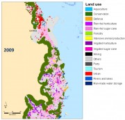
This dataset consist of inputs and intermediate results from the coastal scenario modelling. It is an analysis of the bio-physical factors that best explain the changes in QLUMP land use change between 1999 and 2009 along the Queensland coastal region for the classifications used in the future coastal modelling.
Methods:
The input layers (variables etc) were produced using a range of sources as shown in Table 1. Source datasets were edited to produce raster dataset at 50m resolution and reclassified to suit the needs for the analysis.
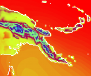
This dataset consists of rasters representing downscaled climate change scenarios (8 km resolution) for the Torres Strait and Papua New Guinea regions for 1990, 2055, 2090. This includes estimated mean surface relative humidity (%), wind speed, rainfall rate (mm per day) and surface temperature (degrees Celsius) estimated from simulated conditions for 1980?1999, 2046-2065 and 2080?2099 time periods. Also included is the relative change of each attribute with respect to 1990.

This dataset contains responses from line (n=53), charter (n=40), and trawl (n=21) fishers to a face-to-face survey about the impacts of the 2004 rezoning of the GBR on commercial fishing activity and commercial fishers.
Data Units:
Quantitative data about fishers attitudes, perceptions, and opinions about the 2004 zoning plan plus spatial data regarding pre- and post-rezoning locations used by fishers.

This dataset provides information about the Australian community's awareness, concern and actions regarding climate change and the GBR. It was aimed at providing a tool for developing effective engagement strategies and future climate change human dimensions research. The dataset contains data from 1,609 telephone surveys of people residing adjacent to the GBR and in the capital cities of Brisbane, Melbourne, and Sydney conducted in November 2008.
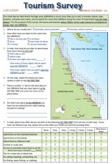
This dataset represents the aggregate of face to face surveys of 2743 visitors to the Great Barrier Reef World Heritage Area (GBRWHA) conducted in quarterly periods from June 2012 to June 2013. This survey was to explore how tourists feel towards and perceive Great Barrier Reef World Heritage Area, as well as their willingness to pay to protect the reef and their satisfaction with current and future developments in and around the GBRWHA.