
Recent datasets
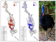
This dataset contains the estimated distribution and abundance of cassowaries across the Wet Tropics Region and the sub-regions used in these estimates. The key areas for cassowary conservation are those with the highest densities and abundance.
This data is based on field surveys and data on cassowary density derived from faecal-DNA analysis of dung samples collected during those surveys.
Methods:

This dataset is derived from the Australia's River Basins 1997 (GA) dataset. It shows the 12 drainage divisions. Primary credit should be given to Geoscience Australia.
This dataset was created by using ArcMap to dissolve polygons from the Australia's River Basins 1997 shapefile based on the DNAME attribute.
The Wet Tropics World Heritage Area (WTWHA) is famous for its wildlife, biodiversity and natural beauty, but none of these important assets are bought or sold in the market place, so none are explicitly ‘valued’ with a price. Recognising that absence of price does not mean absence of value, this project seeks to improve our understanding of the importance of these non-market ‘values’ to a variety of different stakeholders. How important is a beautiful view or a cassowary to the community, to tourists and to the tourism industry?
The low-lying islands of the Torres Strait are vulnerable to climate change and the region faces a range of pressures including a growing population, future climate change, potential pollution as a result of rapid mining and resources development in Papua New Guinea, and increased shipping. Through participatory scenario planning with Torres Strait and PNG communities and stakeholders, informed by integrated ecosystem and climate modelling this project will identify ‘best bet’ strategies to protect livelihoods and achieve sustainable economic development. Tasks include:
Long-term social and economic monitoring helps reef managers understand the current status of marine park users, industries and communities. It also helps build a picture of how industries and communities are likely to respond and cope with changes associated with environmental degradation, climate change, regulatory frameworks, and changes in culture.
This project focuses on understanding the current and future risks and responses of invasive species in the Wet Tropics. The aim is to develop a strategic approach to pest management that considers the complexity of ecological processes involved with establishment and spread and takes account of the values and assets in the region. The project will contribute to the management of invasive plants and animals by providing prioritisation tools that align with existing regional pest management frameworks.
Little is known about the impacts of fire on rainforest vegetation or the animals which depend on it. This project will investigate the positive and negative impacts of fire on rainforest vegetation and wildlife. In collaboration with NPRSR rangers, and where possible with local NGOs and Indigenous Rangers, we propose to establish vegetation and faunal monitoring sites across the rainforest/woodland boundaries and associated vegetation types in key areas of the Mission Beach, Tully lowlands and Hinchinbrook Channel areas to assess faunal and floral status and trends.
This project involved an assessment of all existing and potential sources of pollution to the Torres Strait marine environment. This was combined with information on water movement patterns to assess the hazard (and to some degree risk) of these pollutant sources to marine ecosystems and public health. This project was predominantly a desktop study with some field work to sewage treatment plants, and other point sources of potential pollutants.
This project undertook a scoping study to develop a robust approach that will allow us in Phase 2 to carry out an ecological risk assessment (ERA) of nutrients, fine suspended sediments, and pesticides used in agriculture in the GBR region including ranking the relative risk of individual contaminants originating from priority catchments to the GBR ecosystems using a systematic, objective and transparent approach.
This project will implement monitoring programs for the endangered southern cassowary, Casuarisus casuarius, and the vulnerable spectacled flying-fox, Pteropus conspicillatus.
Cassowary monitoring will be based on regular surveys to collect dung. DNA fingerprinting of the bird dung will provide data on cassowary abundance and distribution, the influence of habitat type and the structure and phylogeography of cassowary populations across the region.
This project is conducting surveys of frogs and other vertebrates in ecotonal areas of the Wet Tropics and Eungella.
This project will map the genetic and phylogenetic diversity of northeast Queensland rainforest plants and fungi with a focus on the mountaintop species, which are regarded as among the most at risk from climate warming. The project consists of two nested subprojects.
This project will act as an integrating focus within the rainforest theme to strategically target research gaps and thereby increase our understanding of the drivers of rainforest biodiversity. We will generate high resolution maps and landscape scale estimates of temporal trends in the condition of biodiversity and environmental changes.
The project consists of four subprojects:
A. Monitoring: Tasks include a microsensor network, standardised vertebrate surveys, habitat structure monitoring and data harvesting from other projects.
This project will examine the status, diversity and condition of mangroves and freshwater habitats in the Torres Strait. This will provide a baseline against which future changes can be assessed and will also enable planning for adaptation to potential sea level rise/increased storm surge. The project builds on Torres Strait Islanders’ knowledge and understanding of mangrove habitats, with scientists working in partnership with Traditional Owners.
This project will:
The Collaborative Australian Protected Areas Database (CAPAD) 2010 provides both spatial and text information about government, Indigenous and privately protected areas for continental Australia. State and Territory conservation agencies supplied data current for various dates between June 2010 and January 2011. This is the eighth version of the database, with previous versions released in 1997, 1999, 2000, 2002, 2004, 2006 and 2008. CAPAD provides a snapshot of protected areas that meet the IUCN definition of a protected area:

This dataset contains line features depicting road classification within the Wet Tropics World Heritage Area. There are five categories of roads in the Wet Tropics World Heritage Area roads where motor vehicle use is allowed by the public. These are as follows:
1. State-controlled road: roads which form part of the State’s road network.
2. Community access road: significant roads for local community transport.
3. Presentation road: roads which provide opportunities for presentation of the WHA
This project focuses on improving methods to detect the introduction of exotic animal diseases into the Torres Strait. The researchers will examine the environmental factors that influence the establishment and persistence of wildlife diseases in the region. They will study insect disease vectors and the incidence of disease in birds in a range of habitats in order to identify where disease risk is greatest. Field studies will be conducted using replicated mosquito trapping and mist netting of birds in Torres Strait, at sites identified from previous projects.
Outcomes include:

This dataset contains polygons depicting geology as deliniated by botanist J.P.Stanton and geologist D.J.Stanton within the Wet Tropics bioregion.
The geology mapping of the Wet Tropics Bioregion is based on interpretation of aerial photographs during WTMAs Vegetation of the Wet Tropics of Queensland bioregion mapping project. Aerial photography was also used to select sites and traverses for ground truthing work. The geological classification and boundaries were based on their relevence to vegetation patterns.

This dataset contains point features depicting mountains, peaks, mountain ranges and hills and their names. Ranges are located with a point or series of points in the approximate vicinity of the feature.
Mountain data originated from 1:250,000 scale AUSLIG supplied topographic data (repromats). Corrections were made to locate the points accurately to the 1:100,000 scale National Topographic Map Series. Georeferenced Topographic Maps are dated 1966.
This dataset consists of a 90 KB point shapefile containing 344 features.
This dataset is a complete state-wide digital land use map of Queensland. The dataset is a product of the Queensland Land Use Mapping Program (QLUMP) and was produced by the Queensland Government. It presents the most current mapping of land use features for Queensland, including the land use mapping products from 1999, 2006 and 2009, in a single feature layer. This dataset was last updated July 2012. The dataset comprises an ESRI vector geodatabase at a nominal scale of 1:50,000 in coastal regions and 1:100 000 in Western Queensland.