
Recent datasets

The Reef Check Australia monitoring program acts as an early warning system for coral community health. Annual surveys provide long-term data that can reveal patterns over time. Trained community volunteers collect quantitative data on the Great Barrier Reef and in the Southeast Queensland coral habitats. Data include substrate percent cover, abundance of key invertebrate species and target fish species. Data on natural and anthropogenic impacts on coral community health are also recorded.

* Catch data from fisheries independent sampling in inshore habitats (inshore reefs, intertidal flats/foreshores, seagrasses and mangroves) of the GBRWHA (Cleveland Bay and Halifax Bay) using bottom-set multihook research lines (long lines) geared to capturing sharks
* Data includes catch and effort data for all species captured.
* Data includes biological data of captured blacktip reef sharks - BTS (Carcharhinus melanopterus).
Sharks play an important role in marine ecosystems but are facing increasing pressure from fishing and other anthropogenic factors. Along the Queensland coast inshore waters play an important role as nursery areas for sharks. However, the same inshore waters are also most prone to fisheries exploitation and effects of freshwater discharge from coastal streams and rivers. This project will examine the importance of different types of inshore habitat (protected bay vs.
Overall the key objectives of this program are to:
1. Identify and map the principal foraging locations for shearwaters and boobies breeding at the most important colonies of the GBR, both within and between breeding seasons, using a combination of different Geolocation, GPS and Satellite PTT data loggers;
2. Obtain detailed information on the biophysical oceanographic characteristics of these foraging habitats in both the GBR and Coral Sea regions using a range of biophysical parameters derived from satellite and in situ data;

This is data associated with MTSRF Task 4.8.4s, a MTSRF supported PhD project titled /Biology and ecology of the blacktip reef shark/. As part of this project, basic water quality data were collected during shark tagging trips at the study site - Cockle Bay Reef at Magnetic Island. The meta data regarding these shark catch and tagging trips are recorded in a separate data file.
Basic water quality of Cockle Bay was measured at weekly to monthly intervals with handheld instruments - a YSI water quality meter (temp, salinity, condutivity, dissolved oxygen), and secchi disk depth.

The purpose of this study was to quantify patterns in skeletal density, linear extension and calcification throughout the GBR based on the AIMS Coral Core Archive of 328 colonies of massive Porites from 69 reefs. Annual data for the three growth parameters, skeletal density, annual extension, and calcification rate (the product of skeletal density and annual extension) were obtained from each colony using standard x-ray and gamma densitometry techniques.

This dataset shows the extent of the dugong sanctuary in the Torres Strait which prohibits the taking of dugong (area, gear and method restrictions).
The dugong sanctuary is a legislative boundary which is outlined in the Torres Strait Fisheries Management Notice No. 65 http://www.comlaw.gov.au/Details/F2007B00345 .
This dataset is for research purposes and is not authoritative. Refer to the legislation for the authoritative definition of the sanctuary.

This dataset shows the location and size of the 9 islands, cays and rocks that make up the Warraberalgahl and Porumalgal Indigenous Protected Area (IPA). The IPA is recognised as part of the National Reserve System and was officially declared on the 18/07/2014.
The declared area covers approximately 63 hectares. The following Islands, Cays and Rocks make up the IPA: Atub, Bara, Bini, Babui, Guiya, Maza Guiya, Miggi Maituin, Ugain and Ulu.

The purpose of this study was to quantify patterns in octocoral biodiversity and their environmental drivers on the GBR. The data are based on visual surveys of octocoral communities (soft corals and sea fans) on 163 GBR reefs. Octocorals contain taxa with and without endosymbiotic microalgae (zooxanthellae), and these two groups have contrasting distributions and ecological niches (Fabricius and De’ath 2008). Richness is therefore presented as number of taxa with and without zooxanthellae.

To date the seabird research program has:
This project will monitor and study dugongs, dolphins and turtles along the coast of the GBRWHA with the following key tasks:
1. Determine the distribution and status of inshore dolphins in the northern Great Barrier Reef World Heritage Area (GBRWHA) by identifying likely important habitats based on collaboration with Tradition Owners and published information, then conduct line transect surveys (along with biopsy samples) in the Cardwell area (Girringun) and Bathurst Bay (far northern GBR).
This dataset contains a series of high resolution raster Digital Elevation Models (DEM) (1m resolution) around the coastal perimeter of Torres Strait community islands (Badu, Boigu, Dauan, Erub, Hammond, Iama, Mabuiag, Masig, Mer, Moa, Poruma, Saibai, Ugar, Warraber). This dataset was developed for the purpose of mapping levels of coastal inundation under different sea level rise and storm tide scenarios.

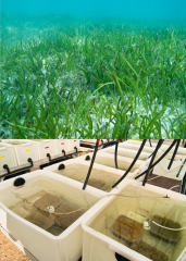
This dataset consists of one data file (spreadsheet) from a 2 week aquarium experiment manipulating pH (pCO2) changes and measuring photosynthetic and growth responses of three tropical seagrass species (Cymodocea serrulata, Halodule uninervis and Thalassia hemprichii).
The aim of this study was to test the hypothesis that increased pCO2 would increase photosynthetic and growth rates to various extents between seagrass species.
Method:

This dataset consists of one csv data file from field derived experiments at tropical carbon dioxide seeps in Papua New Guinea, measuring the response parameters: calcification, photosynthesis, carbon and nitrogen contents and carbon isotopic signatures on Halimeda opuntia grown under ocean acidification conditions.
Turbidity is a measure of water clarity that quantifies the amount of small particles suspended in the water, and is a fundamental environmental parameter influencing coastal marine ecosystems. Turbidity reduces the light needed for photosynthesis by corals and seagrasses, and suspended particles also transport nutrients, pollutants and diseases. Previous research based on 3 years of turbidity data collected from 15 inshore reefs by the Reef Rescue Marine Monitoring Program has shown that it can take several months for water clarity to improve after river floods.
This dataset consists of one data file from a 10 week aquarium experiment manipulating salinity and measuring density, reproduction and growth responses of three tropical Indo-pacific seagrass species (Zostera mueller, Halodule uninervis and Halophila ovalis).
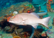
This dataset demonstrates the suitability of microsatellite markers to discriminate between species of coral trout (Plectropomus spp.) and identify parent-offspring relationships in natural populations.
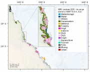
This dataset consists of different possible land use configurations along the Great Barrier Reef coastal zone for the future (year 2035) under eight different scenarios (plausible futures). Scenarios are not predictions and do not intend to show what the coastal zone will look like (this is impossible as the future of coastal development I highly uncertain, even on a short term basis, let alone 25 years). Instead, scenarios are used to depict some plausible futures under certain circumstances so that managers can understand the system better and the various ways the future might unfold.
The database contains native and alien species records for National Park islands in the southern Great Barrier Reef. Attributes for each record include information on abundance, life history traits, habitat requirements, limitations of source, and relevant species information from government bodies including EPBC and NCA listings. Basic interaction information among species (alien vs. native) is also recorded. This dataset also has basic information about the islands such as area, location, and regional ecosystem types present on the island.
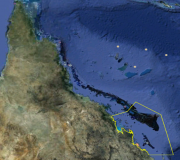
This project will develop a cost-effective approach for prioritising management actions across Great Barrier Reef islands to maximise conservation outcomes. The approach will be broad-based and include pest control, adjustment of fire regimes, biosecurity measures and monitoring. A decision-support tool with GIS capability will help managers to identify management priorities within and between islands.The sub-region selected for this project includes 150 islands within the Great Barrier Reef World Heritage Area from south of Mackay to Bundaberg.