
Recent datasets
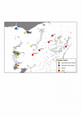
Determining the impact on Torres Strait communities from future changes to ecosystems requires an understanding of the natural resource base that underpins their livelihoods. To do this, we estimate the relative importance of natural resources, or ecosystem goods and services (EGS) to local livelihoods, which in turn is a function of the relative volume of those EGS, and their relative value to human well-being. Our approach was focused on 'provisioning' and 'cultural' EGS, which have a direct link to local livelihoods.
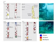
This dataset consists of summaries of benthic, fish and manta tow surveys conducted in the Capricorn-Bunker Region of the Great Barrier Reef in October 2015. It consists of three tables:

Despite the important role Symbiodinium might play we currently have limited knowledge of the distribution ranges of Symbiodinium on the Great Barrier Reef.

The purpose of this study was threefold: (1) to identify water quality guideline values based on existing ecological data; (2) to identify areas where guidelines are met or exceeded, and (3) to quantify the likely ecological changes associated with improving water quality to meet the guidelines.

This dataset corresponds to a shapefile that defines the COTS initiation zone for use in the evaluation of the merit of investment in surveillance and cull and reducing agricultural run off.
The COTS box is a speculative area of primary outbreaks of Crown-of-Thorns Starfish.
This polygon includes Lizard island to the north and Green Island in the south.
Methods:
This dataset consists of 546 records of vertebrate species across various sites in the rainforests and adjacent habitats of the Wet Tropics and the Eungella region. Surveys particularly targeted threatened frogs and focussed on ecotonal and peripheral rainforest areas. Each record consists of the date, species, locality name, latitude and longitude, habitat, and observer.
This dataset consists of 43 thermal ionisation mass spectrometry (TIMS) U-Th dates from living Porites spp. of known ages collected from the far northern, central and southern inshore regions of the Great Barrier Reef (GBR) which were used to spatially constrain initial 230Th/232Th (230Th/232Th0) variability.
Such information is essential in providing accurate chronologies used to pinpoint changes in coral community structure and the timing of mortality events in recent time (e.g. since European settlement of northern Australia in the 1850’s).
Methods:
This dataset is the U-series data for Pelorus Island as described in Roff et al (2013) Palaeoecological evidence of a historical collapse of corals at Pelorus Island, inshore Great Barrier Reef, following European settlement. Proceedings of the Royal Society Series B 10.1098/rspb.2012.2100
Methods:

This dataset shows the point location of communities on Torres Strait Islands. There are 18 Islands in the Torres Strait and 19 Communities. St Pauls and Kubin villages are both located on Moa Island. Each point includes an URL attribute pointing to the community pages on the TSRA website. The Island Communities are:
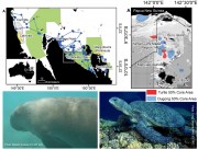
This dataset consists of the home ranges and satellite tracks taken from eleven dugongs and ten green turtles.
Methods:
Fast-acquisition satellite telemetry was used to track eleven dugongs and ten green turtles at two geographically distinct foraging locations in Queensland, Australia to evaluate the inter- and intra-species spatial relationships and assess the efficacy of existing protection zones. Home-range analysis and bathymetric modeling were used to determine spatial use and compared with existing protection areas using GIS.

The eAtlas baselayer is a collection of datasets from third parties styled and combined together to produce a world wide map layer with reasonable detail across the Great Barrier Reef suitable as a baselayer in web mapping applications.
The primary basis for this baselayer is the Natural Earth 2 public domain raster map of the world. Overlaid on this is country outlines, cities and Great Barrier Reefs.
It has a focus on Australia and the Great Barrier Reef and includes a high resolution coast for Australia (100k) and an even high resolution coast for Queensland (50k).
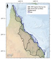
This dataset corresponds to the Natural Resource Management (NRM) Regions corresponding to river catchments neighbouring the Great Barrier Reef Marine Park. The original aim of this dataset was to show river basins that flow into the Great Barrier Reef (GBR) Marine Park, grouping them by their NRM region. The NRM region boundaries already mostly correspond to a grouping of river basin boundaries and so this regrouping of river basins was unnecessary.

Natural Earth is a public domain map dataset available at 1:10m, 1:50m, and 1:110 million scales. Featuring tightly integrated vector and raster data, with Natural Earth you can make a variety of visually pleasing, well-crafted maps with cartography or GIS software.
Natural Earth was built through a collaboration of many volunteers and is supported by NACIS (North American Cartographic Information Society).
Natural Earth Vector comes in ESRI shapefile format, the de facto standard for vector geodata. Character encoding is Windows-1252.
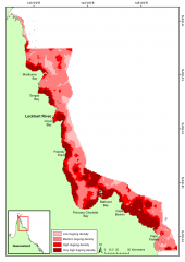
This dataset shows a raster spatial model of the distribution and relative density of dugongs (Dugong dugong) in the northern Great Barrier Reef region based on an aggregate of 24 years (1990 - 2013) of systematic aerial surveys.
Methods:
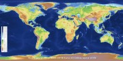
This dataset corresponds to a reformatting of the SRTM30_PLUS digital elevation dataset from 33 NetCDF files into a single GeoTiff for use in GIS applications. No other modifications to the data were done. The rest of this metadata describes the original SRTM30_PLUS dataset itself.
Note: The SRTM15_plus dataset is a similar more recent, higher resolution bathymetry dataset https://topex.ucsd.edu/WWW_html/srtm15_plus.html.

The purpose of this study was to provide a large-scale documentation of the extent of bleaching, for comparison against SST and other bleaching events.
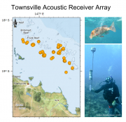
There are 3 datasets:
1. Acoustic array - this dataset includes a description of the acoustic array deployed on reefs offshore from Townsville. The array was in place from August 2011 to December 2014.
2. Individuals tagged - this dataset includes a description of the individuals fitted with acoustic transmitters for tracking on an acoustic array deployed on reefs offshore from Townsville.

This dataset is shows the distribution of inshore seagrass along the eastern Queensland coastline. It is a composite of 38 surveys conducted from 1984 to 2007.
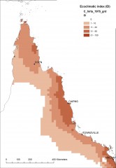
This dataset shows the projected current and future (2070) climatic suitability for the invasive plant species Clidemia hirta, Hiptage benghalensis, Miconia calvescen, Miconia nervosa, Miconia racemose, Stevia ovata,and Turbina corymbosa across North Queensland. Modelled using CLIMEX.
Method:

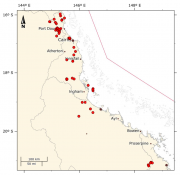
This dataset contains the voyage data from the crown-of-thorns starfish (COTS) control program operated by the Association of Marine Park Tourism Operators (AMPTO) from the Cairns to Lizard island region. It contains the data from two control vessels (MV Hero and MV Venus II) with a total of 64 voyages, each of 10 days.