
Recent datasets
The exposure of Great Barrier Reef coral reef and seagrass ecosystems to contaminants is estimated from the synthesis of: river discharge, water quality data sampled in inshore sites during flood conditions and the use of remote sensing technology to estimate flood plume extents and duration.
Our current knowledge of the mechanisms that affect diversity of plants and animals on the Great Barrier Reef (GBR) is minimal. This project will map the diversity of groups of organisms and environments of the GBR using existing long-term and large-scale data, and relate biotic diversity to spatial, environmental and temporal drivers. These relationships will be interpreted in the context of risk, zoning and management. Outcomes include:
1. Online interactive maps of the diversity of fishes, corals, other organisms and environments of the GBR.
The Reef Rescue Marine Monitoring Program (RRMMP) has identified that seagrass meadows along the Great Barrier Reef are in a state of decline. This project will undertake desktop analyses to quantify the exposure of seagrass meadows to flood plumes. Aquaria experiments will measure responses of seagrass to variation in light, nutrients and salinity. This project will also use use True Colour Remote sensing images, to derive flood plume exposure and relate to changes in seagrass abundance and composition.
This dataset corresponds to a database of datasets that are relevant for the development of coastal development scenarios and impact assessments GBR. It corresponds to a list of all the datasets that were sourced as part of project 9.4. It contains basic information about each dataset along with the license that each dataset was obtained under and where the data can be sourced. This database is an excellent starting point for any others looking at obtaining data relevant for coastal management.
Methods:

The purpose of this study is to detect and quantify spatial and temporal changes in benthic communities and juvenile coral assemblages of the Great Barrier Reef (GBR). Additionally, spatial and temporal variation in sources of coral mortality are monitored to assist with interpretation of changes in benthic assemblages. Between 1993 and 2005, benthic assemblages of 46 reefs were monitored annually along permanent transects within a standard habitat using underwater video/digital still photography.
The values of the Great Barrier Reef World Heritage Area (GBRWHA) are threatened by coastal development through habitat loss and runoff of sediment, nutrients and pollutants. Future coastal development is difficult to predict because it depends on volatile socio-economic and political factors. With this in mind, we developed a research project that uses spatially explicit scenario planning to identify plausible futures to 2035 for the GBRWHA coastal zone. The method used to produce maps of these scenarios is land-use change modelling using the GIS Idrisi.

This dataset contains telephone (n=1743), mail (n=800), and face-to-face (n=132) survey data collected from the recreational fishing community in the Great Barrier Reef region. The surveys were aimed primarily at understanding fishers' attitudes and perceptions regarding the 2004 rezoning of the GBR and the impacts of the new zoning plan on recreational fishing activity and the spatial distribution of recreational fishing effort.

This dataset consists of site and zone means of the percent cover of major benthic categories and the density of fish functional groups on fringing coral reefs of the Keppel, Whitsunday and Palm Island groups, as a result of monitoring surveys carried out between 1999 and 2014.
This data extract summarises the results of a long-term monitoring project that assesses the effects of no-take marine reserve zoning in the Great Barrier Reef Marine Park.
This project will conduct a biodiversity assessment of coral communities on Torres Strait reefs to establish a baseline of coral condition and start a longer-term monitoring program of selected coral reefs in the region. The monitoring will look for changes in the condition of coral reefs and document factors that might contribute to changes incl COTS, disease, bleaching, temperature anomalies etc. As part of this project, an early warning system will be established for coral bleaching.

The purpose of this study was to quantify patterns in scleractinian biodiversity, and in the cover of the main benthos groups, on the Great Barrier Reef. Taxonomic surveys of hard corals conducted on 110 reefs (599 transects) of the GBR between 1994 and 2001. Surveys are based on rapid ecological assessments (taxonomic inventories based on swim surveys) conducted at two depth zones (deep and shallow), typically at two sites per reef. The data are abundance estimates of each species. Richness is calculated based on reef-averaged data.
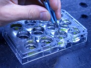
This dataset shows the measured response of the photosystems of seagrasses to herbicides in experiments conducted in 2014. The purpose of the experiments were to develop and validate a miniature toxicity assay using isolated seagrass leaves in 12-well plate.

Depth and Elevation Model of the Great Barrier Reef (GBRDEM), a regional-scale terrain model covering the Great Barrier Reef, catchments which flow into the Great Barrier Reef and, where data are available, depths beyond the edge of the continental shelf. Data are presented as Mean Sea Level (MSL, unit: m), a measure indistinguishable from the Australian Height Datum (AHD) in accuracy at the regional scale.

This dataset consists of an atlas of the habitat quality of the urbanized and agricultural landscapes of the Mission beach region in August 2006, 6 months after cyclone Larry. This analysis and classification includes habitat quality, canopy cover, vegetation quality, vegetation types, tenure type and aerial photography at a resolution of 0.5m.
These maps of habitat quality highlight potential priority areas for maintenance and/or restoration of connectivity and is a tool for natural resource managers to implement restoration goals at Mission beach.
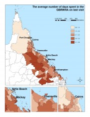
This data set in excel sheet format presents results of the mail survey of 1565 residents of the GBRWHA. The dataset is accompanied by a set of 58 maps that illustrate key findings.
Project 10.2 explored how visitors and residents feel towards and perceive Great Barrier Reef World Heritage Area, as well as their willingness to pay to protect the reef and their satisfaction with current and future developments in and around the GBRWHA.

This data set contains life history data from 46 species of coral reef fish from four families (see list below). The data and samples on which these analyses are based were collected as part of the Effects of Line Fishing Project and the East Torres Strait Coral Reef Fishery Project. Species included in this data set include:
Labridae: Cheilinus undulatus, Choerodon cyanodus, C. fasciatus, C. schoenleinii, C. venustus
Lethrinidae: Lethrinus atkinsoni, L. lentjan, L. nebulosus, L. olivaceus

Pattern of seagrass distribution in the Great Barrier Reef World Heritage Area

The purpose of this study was to characterise spatial and temporal patterns in sea surface temperatures in the Great Barrier Reef.

This study characterises spatial patterns in water clarity. Water clarity is a key indicator for water quality and is an essential environmental factor for phototrophic organisms that dominate coral reefs, seagrass meadows and the seafloor microphytobenthos. Secchi disk depthis a commonly used standardised way to quantify water clarity.

Trajectories of decline have been observed in coral reefs throughout the Caribbean and Indo-Pacific region attributable to the synergistic effects of human-induced disturbances. Whilst direct and indirect evidence suggests that inshore reefs from the Great Barrier Reef (GBR) are showing signs of regional decline following European settlement in the mid 18th century, it has proven difficult to ascertain the link between anthropogenic disturbance and coral degradation on a regional scale.

The aims of this work (MTSRF Project 1.1.3b) were to identify the role of light and water temperature as drivers of change in seagrass meadows of the northern Great Barrier Reef. Experimental approaches as well as field investigations were undertaken.